

The concept of Pangaea is pretty well-known, but not many people know what exactly it looked like, or how the continents changed through time. Martin Ince’s Continental Drift charts out the changing face of the globe, depicting maps of the Earth as it would have appeared at several key points in history, along with a few pages on major events and lifeforms of the time. (One can also find this book under the simpler title of Drift, though it seems to be the older edition.)

The book is divided into sections based on the particular time and geographic arrangement under consideration. Kenorland is the earliest depicted, at 2.7-2.1 billion years ago but doesn’t get its own section. It appears oddly enough as an insert within a discussion about the origin of both land and life. As both of these events occurred at least a full billion years before the formation of Kenorland, I’m not sure why this continent was selected for the book. Perhaps it’s due to the scarcity of information about earlier continents, as the hypothesized prior landmasses of Ur and Vaalbara are difficult to reconstruct, and perhaps even dubious.

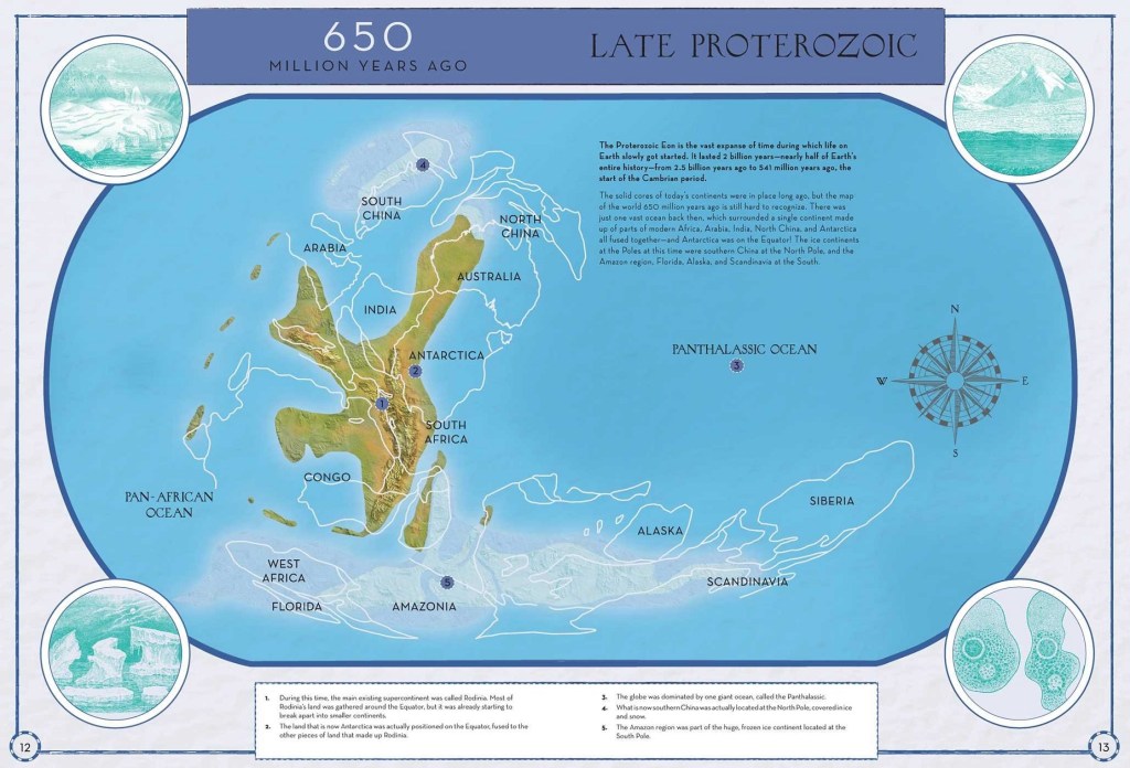
The book then skips ahead to the supercontinent of Rodinia, 650 million years ago (mya) during the event known as “Snowball Earth” (a dramatic incident of climate change, apparently caused by photosynthetic cyanobacteria changing the ratio of carbon dioxide & oxygen in the atmosphere).
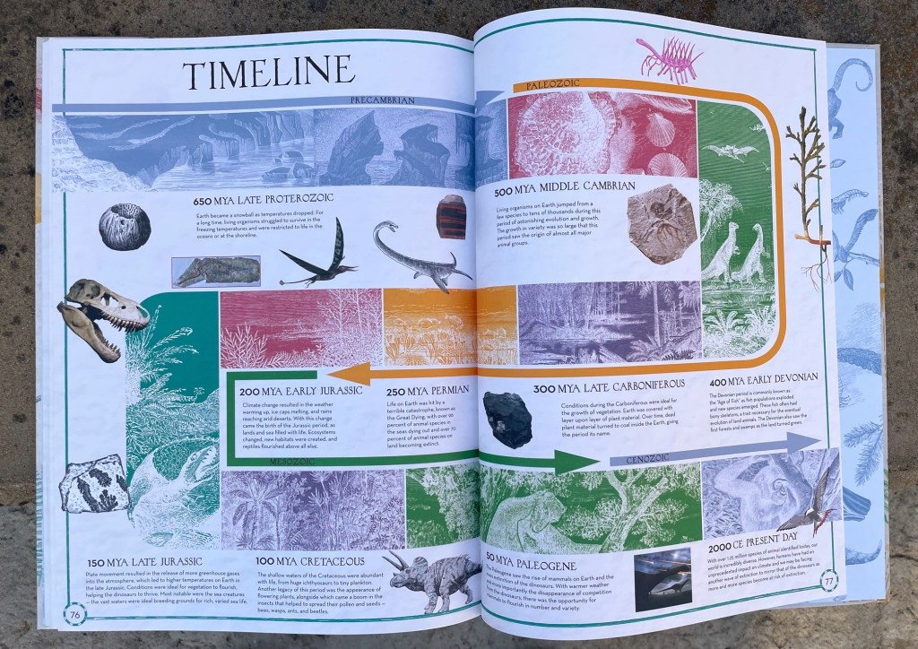
From here we check in on the progression at semi-regular intervals:
- the Cambrian Period, 500 mya
- the early Devonian, 400 mya
- the Carboniferous, 300 mya
- the Permian, 250 mya
- the Early Jurassic, 200 mya
- the Late Jurassic, 150 mya
- the Cretaceous, 100 mya
- the Paleogene, 50 mya
- the Anthropocene, aka modern times
- and even the projected shape of the continents 50 mya into the future, based on the current speed & direction of continental drift!

For all its fame in popular media, it’s remarkable to realize that Pangaea only existed in its complete form a little over 100 million years, out of the Earth’s total of 4.5 billion years. Indeed, its smaller constituent supercontinents of Laurasia & Gondwana feel more significant as we watch their movements across the pages of the book, as it was the collision of these two, and their subsequent breakup, that ruled the relatively brief fate of Pangaea itself.
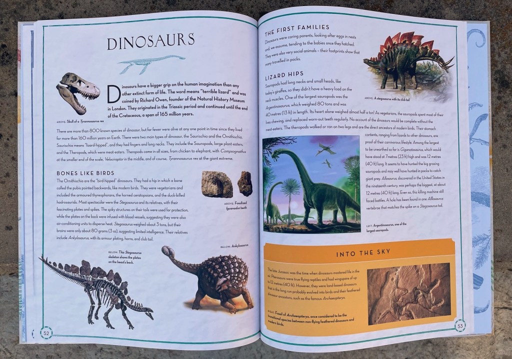
The maps certainly accomplish the books primary aim of impressing and educating the readers about our planet’s history. The additional pages included with each one help round out this experience, as well as grounding readers with other significant events they might find familiar, such as the evolution of land-dwelling tetrapods, the Great Dying, the rise of the dinosaurs, and so on.

I did note a few errors, at least one of them fairly significant, unfortunately. The most egregious was the photo of a crinoid (or sea lily) fossil, which was even correctly labeled Eucladocrinus pleuroviminus, and yet the book somehow thinks this flower-shaped creature is an example of a land-dwelling vertebrate! On the same page a painting of what is clearly a modern lungfish is misidentified as Tiktaalik. It’s not even the robust-limbed Queensland Lungfish, either, but one of the more ribbon-limbed species. At least this time it’s a close sister taxa to the one in question, but it’s still an embarrassing flub.
The book’s penchant for vintage art also makes for a few other misleading illustrations, even if they aren’t outright mistakes (at least to the degree of the previous examples). The example that stands out most to me in this case is when a Crystal Palace illustration is used to portray Dicynodon; not only does the book fail to note that this model is incredibly out of date, but the way the picture is framed, it seems to imply that it is discussing the Labyrinthodon model, rather than the actual Dicynodon models which hang out in the background.
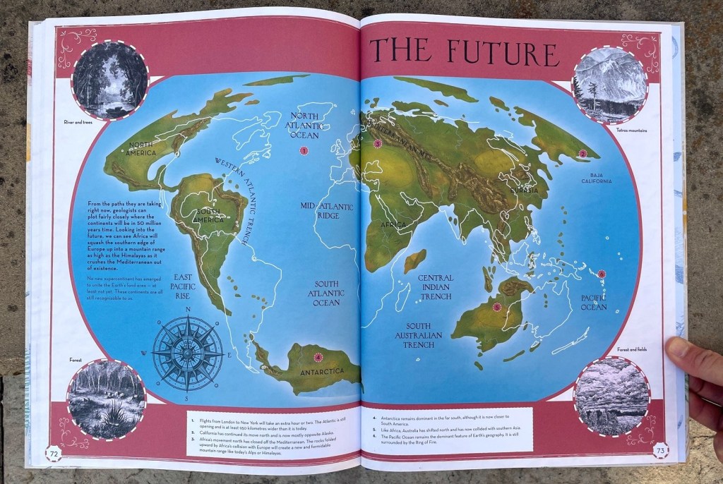
I final issue I’ll note, primarily because it effects the otherwise-excellent map illustrations: in the map depicting the globe of 50 million years hence, it does not depict the separation of East Africa from the rest of the continent, despite mentioning this eventuality when discussing the Great Rift Valley in the section on the modern day. It’s possible the collision of the rest of Africa into Eurasia will somehow squeeze things in such a way as to prevent full separation, but no mention of this is made.
Like Pangaea contextualized against Earth history, however, these admittedly large errors affect a relatively small portion of the book, and would be easy to correct in future publications. (In fact, as I have the earlier Drift variant of the book, its possible some of these have since been corrected, though this does not seem apparent when I look at previews of the new edition.) I still can’t help but like it, overall. It handily accomplishes its main purposes of portraying the changes that Earth has gone through, and is still an incredibly useful visual aid in that regard. The errors don’t necessarily detract from that aspect, and while they prevent me from giving it my full “Stomp of Approval”, I still highly recommend checking out Continental Drift if you happen to come across it!
If you would like to know how we came to prove that the continents do in fact move over time, check out the story of Marie Tharpe, particularly my reviews of both Ocean Speaks and Marie’s Ocean (as well as her funky ballad performed by The Amoeba People). To learn about the rock cycle, which factors into continental drift, check out the humorous book with a slight touch of gross-out-humor, A Dinosaur Made Me Sneeze!

One comment